:format(jpeg)/cloudfront-us-east-1.images.arcpublishing.com/tgam/XB5DM4S7GFFG7BDHQQIETQHTJQ.jpg)
The Anthropocene has gained a Canadian starting line.
On Tuesday, an international panel of scientists announced that Crawford Lake, a small body of water located 50 kilometres west of Toronto, has emerged from among a dozen candidates around the world as the place that best records the dawn of the human epoch.
That epoch, they say, began during the middle of the 20th century, when our species effectively became the main driver of global change.
Those who study Earth as an interconnected system maintain that this transition marks not only a turning point in history, but the beginning of a new interval in geologic time. And while the Anthropocene is unfolding everywhere around the world, its arrival was preserved with unusual precision at Crawford Lake.
“We are finding tangible, measurable evidence of what happened and when it happened,” said Francine McCarthy, a professor of Earth science at Brock University in St. Catharines.
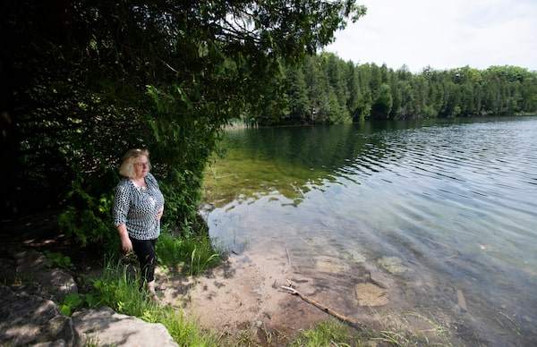
Francine McCarthy has been conducting research related to Crawford Lake since she was a graduate student. Its selection at the "golden spike" site that marks the start of the Anthropocene is the culmination of a five-year effort.Fred Lum/The Globe and Mail
The notion that an entire unit of geologic time can be tied to something so recent has yet to be endorsed by the broader community of experts who discuss, divide and characterize the successive layers of rock that make up Earth’s 4.5 billion year history. But Tuesday’s announcement, made during a meeting of the International Commission on Stratigraphy in Lille, France, brings the scientific case for the Anthropocene one step closer to acceptance. And for the first time, it ties the concept to a specific place.
That the place has turned out to be Crawford Lake is a coup for Dr. McCarthy and her colleagues. For the past five years they have been on a quest to document the lake and make the case for its selection as the archetypal site that defines the Anthropocene.
In scientific parlance, any such location is called a Global Boundary Stratotype Section and Point, or GSSP. By custom, its position is marked with a golden spike (which needn’t be real gold) that is hammered into an exposed section of rock to mark the beginning of the relevant stratum.
A physical spike would not be practical at Crawford Lake, where the start of the Anthropocene has provisionally been identified with a wafer-thin deposit of sediment located under 22 metres of water plus several more centimetres of mud. Should the Anthropocene ultimately win recognition as a distinct unit of geologic time, its corresponding GSSP is more likely to be identified on a detailed photo of a core sample that was extracted from the lake earlier this year.
In the meantime, Tuesday’s announcement is certain to bring a new level of international attention to Crawford Lake and a new clarity about what the Anthropocene really means. “If this definition of the Anthropocene is used from Crawford Lake, then everybody will know what we’re talking about and we’ll all know we’re talking about the same thing,” said Alwynne Beaudoin, president of the Geological Association of Canada, who was not involved with the Crawford Lake effort.
:format(jpeg)/cloudfront-us-east-1.images.arcpublishing.com/tgam/HSDUVJD5SFAEZNQKZDEUJDDVIY.jpg)
:format(jpeg)/cloudfront-us-east-1.images.arcpublishing.com/tgam/ONNK6WW4XFACTCWGRFLM73M3LU.jpg)
:format(jpeg)/cloudfront-us-east-1.images.arcpublishing.com/tgam/UU35M6FY4RAVFEOIU5LVUMRMGE.jpg)
:format(jpeg)/cloudfront-us-east-1.images.arcpublishing.com/tgam/BEIWUU4QUNDYJOQ4LZTOCDKI6Y.jpg)
The Anthropocene debate
The word Anthropocene appears so frequently in the media that people can be forgiven for thinking it enjoys a similarly well-established presence in geology textbooks. This is not the case.
While few doubt that humans have had an extraordinary impact on the planet, the question for scientists is whether this qualifies as the start of a new chapter in the long saga of Earth.
Experts still debate whether the Holocene, the 12,000 year stretch that has elapsed since the end of the last Ice Age, is long enough to be considered as separate from the 2.57 million year-old Pleistocene that preceded it. In comparison, an epoch that is shorter than some people have been alive seems to break the definition of a geological timescale.
But if the point is change rather than duration, the Anthropocene has a strong case. That was the contention of Paul Crutzen, a Dutch atmospheric chemist and Nobel laureate who began to popularize the term in 2000, and who noted that planetwide changes that human are causing today will still be in evidence far into the future.
Mr. Crutzen, who died in 2021, suggested that rising emissions of carbon dioxide, which began with the Industrial Revolution, can be taken as the moment when the Anthropocene got under way. The problem for geologists is that the Industrial Revolution happened at different times in different places. Evidence of that transition does not line up in a consistent way around the world – the basic requirement for designating a spot on Earth’s timeline.
An alternative choice can be found in the 1950s when there was a clear inflection point in several key trends related to humanity’s impact on the planet. It includes the burning of fossil fuels, water consumption, use of mineral-based fertilizers and human population growth, among other indicators.
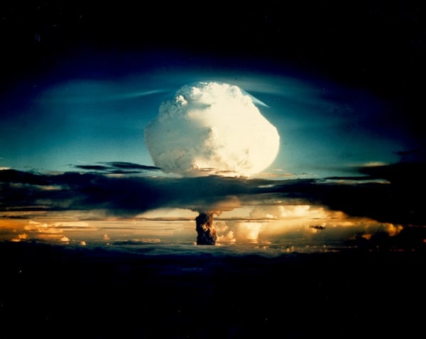
A hydrogen bomb is detonated on Enewetak Atoll, part of the Marshall Islands, on October 31, 1952. This and subsequent tests spread plutonium isotopes around the world until the first nuclear test ban treaty in 1963.Handout
Known as “the great acceleration,” this period also left an unmistakable calling card in the form of plutonium isotopes, created during nuclear weapons testing, that were lofted into the atmosphere and distributed simultaneously around the globe.
“The scale of change was so great and so rapid – well outside the variability you see in the Holocene. That made it clear to us that it’s not the Holocene anymore,” said Colin Waters, a British geologist who chairs the Anthropocene Working Group.
The working group was launched by the international geological community to determine whether there is a scientific basis for the Anthropocene and, if so, to identify an appropriate location to mark it.
That last point is crucial, said Lucy Edwards, a scientist emeritus with the US Geological Survey who has closely followed the Anthropocene debate.
“The fact of the matter is if you want to be part of the geological timescale, you must have a site – something you can touch – to be the definition of that series in the [chronological] record,” she said.
A walk through time
Standing beside Crawford Lake on a breezy summer day, it’s easy to forget how ubiquitous humanity’s footprint on the planet has become.
Today, the lake is an oasis rimmed with trees. But it began as a subterranean chamber, hollowed out by water running through the limestone bedrock of the Niagara Escarpment. By the time the great Laurentide ice sheet retreated – roughly 13,000 years ago in this part of Canada – the chamber roof had collapsed, leaving a deep, water-filled pocket open to the sky.
And grain by grain, silt began to collect at the bottom of the newborn lake.
Through the centuries, the environment around the lake shifted from Arctic tundra to temperate forest. During one 2,800-year stretch, the climate dried out and the lake level dropped. But then it rose again, the silent waters accumulating and preserving each change.
Next came the farmers. Indigenous people built longhouses and cultivated the soil starting around 1300, based on corn pollen found in the lake sediment. They also left a series of distinct layers, called varves, that reveal the passage of years. A new varve was added every summer when algae, fed by nutrients from human waste among other sources, lowered the acidity of the lake and caused calcium carbonate to precipitate out, forming a white residue on the lake bed. But by the 1500s, the varves were gone and so were the Indigenous farmers, possibly because of a cooling climate or Old World diseases which swept the continent far in advance of European settlers.
Crawford family members on Crawford lake in a rowboat in this undated photo.Conservation Halton/Handout
A few centuries more and those Europeans were now busy settling by the lake, clearing the land and planting crops. In 1883, George Crawford bought the lake and established a sawmill there. By then the varves had reappeared, the chemistry of the lake once again altered by the surrounding activity.
So it went until 1969, when George’s grandson Lloyd Crawford sold the property to what was then the Halton Region Conservation Authority. Today the lake sees about 100,000 visitors per year and has become one of the gems of the Niagara Escarpment, designated a UNESCO world biosphere reserve in 1990.
“It’s amazing to be the steward of a site like this,” said Craig Machan, director of parks and operations for Conservation Halton, during a walk beside the lake. “How many places can say that they’ve got something that’s unique to the world?”
Plumbing the depths
The first person to pull a sediment core out of Lake Crawford was John (Jock) McAndrews, now 90, a paleoecologist and curator at the Royal Ontario Museum who began investigating the lake in the early 1970s. It was his graduate student, Maria Boyko, who first discovered the corn pollen in the mud, which in turn prompted an archeological survey and the discovery of the traces of longhouses near the lake. More studies revealed the lake’s two-part structure – with a cold bottom section that is prevented from mixing with the top, thereby keeping the varve layers intact.
The device used to gather the lake sediment is called a freeze corer. It is packed with dry ice, then lowered down into the lake bottom. The mud there freezes to the surface of the corer, forming a rind that can be withdrawn in one piece, preserving the annual sequence of varves.
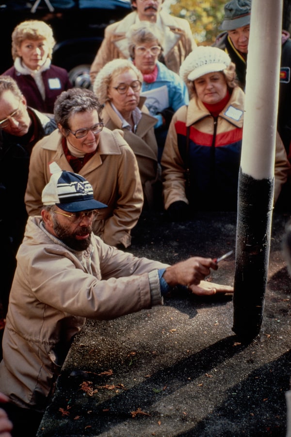
ROM Curator Emeritus John "Jock" McAndrews explaining the stratigraphy of a varved sediment core to a group of visitors at Crawford Lake in the 1980'sRoyal Ontario Museum/Handout
“This is part of Jock’s legacy,” said Dr. Deborah Metsger, assistant curator of botany at the ROM who also participated in studies of the lake. “There are things right in our backyard that have global significance.”
Years later, it was Dr. McCarthy, another former student of Dr. McAndrews, who would lead the effort to understand if Crawford Lake fit the criteria for the Anthropocene gold spike. For those studies, attention shifted to the topmost layers of sediment, including those that bear the telltale plutonium isotopes.
Dr. McCarthy said that not until an analysis found plutonium in the lake sediment was she certain that Crawford Lake has all the ingredients to vie for the golden spike site.
“Even though every other aspect of what we had was off the charts good, if we didn’t have a strong plutonium record, all of that other stuff would have mattered little,” she said.
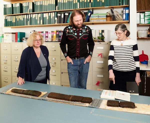
Francine McCarthy together with Royal Ontario Museum researchers Soren Brothers and Deborah Metsger examine a core sample collected at Crawford Lake in 2022. A clear shift from a brownish tinge to a darker grey colour corresponds to changes in the lake's microbial population and chemistry following the arrival of European settlers.Courtesy of Royal Ontario Museum/Handout

The Quest for the “Golden Spike”
Twelve locations around the world were initially proposed as potential “golden spike” sites that preserved a clear record of the onset of the Anthropocene, a proposed geological epoch that marks the arrival of humanity as a planet-altering force around 1950. Crawford Lake in Canada was ultimately selected. The lake sits in a hollowed-out pocket of limestone atop the Niagara Escarpment, west of Toronto. In prior centuries the location was settled by Indigenous farmers. It became a conservation area in 1969.
CANDIDATE SITES
8
1
10
2
6
9
4
7
3
11
12
5
Crawford Lake, Ont.
1
2
San Francisco Estuary, Calif.
Searsville Lake, Calif
3
West Flower Garden Bank Reef, U.S.
4
Antarctic Peninsula
5
Sniezka Peatlands, Poland
6
Ernesto Cave, Italy
7
East Gotland Basin, Baltic Sea
8
Karlsplatz, Austria
9
Sihailongwan Lake, China
10
Beppu Bay, Japan
11
Flinders Reef, Australia
12
CRAWFORD LAKE, ONTARIO
Niagara
Escarpment
Hwy 401
ONT.
Milton
Outlier
Appleby Line
Guelph Line
Crawford
Lake
Conservation Rd
Derry Rd
1 km
Why Crawford Lake?
Crawford Lake’s selection was aided by the fact that it has been the site of scientific study for more than 50 years. In the 1970s, researchers learned that it is really two lakes in one. Water in the upper sections circulates and is in contact with the atmosphere. The deepest layer is isolated. Unlike most such lakes, the deep layer remains oxygenated because of incoming groundwater. Seasonal changes in the chemistry of the lake trigger the formation of calcium-rich crystals that settle to the bottom, forming annual layers called varves that lie undisturbed. When core samples are extracted from the lake bottom, the varves allow scientists to accurately locate key moments in the climate, ecological and historic record, including the 1930s dust bowl and the appearance of plutonium isotopes from nuclear weapons tests in the 1950s — the key indicator used to define the Anthropocene.
Depth
CROSS-SECTION
0 m
Dust, pollen, organic matter and other particles
Upper
layers
10
No varves
Groundwater
Varves
Lower
layer
20
Limestone
bedrock
0
50
100
150
200
250
300 m
Distance
(south–north)
The core
The Anthropocene is currently associated with a start date at 1950. Plutonium isotopes in the 1952 layer of the core sample correspond to the first test of a hydrogen bomb, which took place in the Pacific Ocean that year.
0 cm
2010
2000
1990
1980
10
1970
1867–present
1960
1950
1940
1930
20
1920
1910
1900
1890
1880
1870
30
Post-Indigenous
agriculture:
~1500 to 1867
40
Indigenous
agriculture:
~1300 to ~1500
50
60
Pre-Indigenous
agriculture
MURAT YÜKSELIR / THE GLOBE AND MAIL, SOURCE:
ANTHROPOCENE-CURRICULUM.ORG; OPENSTREETMAP

The Quest for the “Golden Spike”
Twelve locations around the world were initially proposed as potential “golden spike” sites that preserved a clear record of the onset of the Anthropocene, a proposed geological epoch that marks the arrival of humanity as a planet-altering force around 1950. Crawford Lake in Canada was ultimately selected. The lake sits in a hollowed-out pocket of limestone atop the Niagara Escarpment, west of Toronto. In prior centuries the location was settled by Indigenous farmers. It became a conservation area in 1969.
CANDIDATE SITES
8
1
10
2
6
9
4
7
3
11
12
5
Crawford Lake, Ont.
1
7
Ernesto Cave, Italy
2
East Gotland Basin,
Baltic Sea
8
San Francisco Estuary, Calif.
3
Searsville Lake, Calif
Karlsplatz, Austria
9
4
West Flower Garden
Bank Reef, U.S.
Sihailongwan Lake, China
10
Beppu Bay, Japan
5
11
Antarctic Peninsula
Flinders Reef, Australia
6
12
Sniezka Peatlands, Poland
CRAWFORD LAKE, ONTARIO
Niagara
Escarpment
Hwy 401
ONT.
Milton
Outlier
Appleby Line
Guelph Line
Crawford
Lake
Conservation Rd
Derry Rd
1 km
Why Crawford Lake?
Crawford Lake’s selection was aided by the fact that it has been the site of scientific study for more than 50 years. In the 1970s, researchers learned that it is really two lakes in one. Water in the upper sections circulates and is in contact with the atmosphere. The deepest layer is isolated. Unlike most such lakes, the deep layer remains oxygenated because of incoming groundwater. Seasonal changes in the chemistry of the lake trigger the formation of calcium-rich crystals that settle to the bottom, forming annual layers called varves that lie undisturbed. When core samples are extracted from the lake bottom, the varves allow scientists to accurately locate key moments in the climate, ecological and historic record, including the 1930s dust bowl and the appearance of plutonium isotopes from nuclear weapons tests in the 1950s — the key indicator used to define the Anthropocene.
Depth
CROSS-SECTION
0 m
Dust, pollen, organic matter and other particles
Upper
layers
10
No varves
Groundwater
Lower
layer
Varves
20
Limestone
bedrock
0
50
100
150
200
250
300 m
Distance
(south–north)
The core
The Anthropocene is currently associated with a start date at 1950. Plutonium isotopes in the 1952 layer of the core sample correspond to the first test of a hydrogen bomb, which took place in the Pacific Ocean that year.
0 cm
2010
2000
1990
1980
10
1970
1867–present
1960
1950
1940
1930
20
1920
1910
1900
1890
1880
1870
30
Post-Indigenous
agriculture:
~1500 to 1867
40
Indigenous
agriculture:
~1300 to ~1500
50
60
Pre-Indigenous
agriculture
MURAT YÜKSELIR / THE GLOBE AND MAIL, SOURCE:
ANTHROPOCENE-CURRICULUM.ORG; OPENSTREETMAP

The Quest for the “Golden Spike”
Twelve locations around the world were initially proposed as potential “golden spike” sites that preserved a clear record of the onset of the Anthropocene, a proposed geological epoch that marks the arrival of humanity as a planet-altering force around 1950. Crawford Lake in Canada was ultimately selected. The lake sits in a hollowed-out pocket of limestone atop the Niagara Escarpment, west of Toronto. In prior centuries the location was settled by Indigenous farmers. It became a conservation area in 1969.
CANDIDATE SITES
East Gotland
Basin, Baltic Sea
Crawford
Lake, Ont.
Sihailongwan
Lake, China
San Francisco
Estuary, Calif.
Sniezka
Peatlands,
Poland
Karlsplatz, Austria
Ernesto
Cave, Italy
West Flower
Garden Bank
Reef, U.S.
Beppu Bay, Japan
Searsville Lake, Calif
Flinders Reef,
Australia
Antarctic Peninsula
CRAWFORD LAKE, ONTARIO
Niagara Escarpment
Hwy 401
Milton
Outlier
Tremaine Rd
Appleby Line
Guelph Line
Crawford
Lake
ONT.
Conservation Rd
Derry Rd
1 km
Why Crawford Lake?
Crawford Lake’s selection was aided by the fact that it has been the site of scientific study for more than 50 years. In the 1970s, researchers learned that it is really two lakes in one. Water in the upper sections circulates and is in contact with the atmosphere. The deepest layer is isolated. Unlike most such lakes, the deep layer remains oxygenated because of incoming groundwater. Seasonal changes in the chemistry of the lake trigger the formation of calcium-rich crystals that settle to the bottom, forming annual layers called varves that lie undisturbed. When core samples are extracted from the lake bottom, the varves allow scientists to accurately locate key moments in the climate, ecological and historic record, including the 1930s dust bowl and the appearance of plutonium isotopes from nuclear weapons tests in the 1950s — the key indicator used to define the Anthropocene.
Depth
CROSS-SECTION
0 m
Dust, pollen, organic matter and other particles
Upper layers
10
No varves
Groundwater
Varves
20
Lower layer
Groundwater
Limestone bedrock
0
50
100
150
200
250
300 m
Distance (south–north)
The core
The Anthropocene is currently associated with a start date at 1950. Plutonium isotopes in the 1952 layer of the core sample correspond to the first test of a hydrogen bomb, which took place in the Pacific Ocean that year.
0 cm
2010
2000
1990
1980
10
1970
1867–present
1960
1950
1940
1930
20
1920
1910
1900
1890
1880
1870
30
Post-Indigenous
agriculture:
~1500 to 1867
40
Indigenous
agriculture:
~1300 to ~1500
50
60
Pre-Indigenous
agriculture
MURAT YÜKSELIR / THE GLOBE AND MAIL, SOURCE: ANTHROPOCENE-CURRICULUM.ORG; OPENSTREETMAP
A new ground zero
Among the sites that the Anthropocene Working Group settled on as finalists for the golden spike were several lakes and marine basins, a river estuary, two coral reefs, a cave in Italy, a peat bog in Poland, and a section of ice from the Antarctic Peninsula.
Dr. Waters said that Crawford emerged as the favourite because of a combination of factors, but the other sites were equally important to document.
“When you combine it with the other 11 sites across five continents, then you start to see a much bigger picture of environmental change happening in the 20th century.”
At least one wrinkle about the final selection has yet to be ironed out, which relates to the exact date of the GSSP. The working group previously established 1950 as the year that marks the transition to a new epoch, but at Crawford, the plutonium fallout starts showing up as a clear signal in 1952.
Meanwhile, the proposal that Anthropocene is a geologic epoch, with Crawford Lake as its representative, now advances to the next level and, if it succeeds, to a vote by the International Commission on Stratigraphy. The whole idea can still be vetoed by the International Union of Geological Sciences, which holds a congress once every four years and is next set to meet in Korea in the summer of 2024.
But the fact remains that the Anthropocene has already become a useful concept for those outside the geological community, as a way to explain the unique and perilous moment that humanity finds itself in.
“I’m hoping that whatever comes of this, it is going to result in conversations – and that these conversations lead to a better understanding of how profoundly our planet is changing at every level,” said Tim Patterson, a geologist at Carleton University in Ottawa, whose lab has investigated most of the recent core samples from Crawford Lake.
The point raises a question of whether the Anthropocene is really about the past, as other geological divisions of time are, or about a future that has yet to be written into the record.
“We have a deep relationship with the planet,” said Soren Brothers, the Royal Ontario Museum’s recently appointed curator for climate change. “The planet is responding to everything we do. So then maybe the Anthropocene is really about what we do with that relationship.”
:format(jpeg)/cloudfront-us-east-1.images.arcpublishing.com/tgam/A6KL4VGLVFCSTP6RRVOS2H3HV4.jpg)
 Ivan Semeniuk